


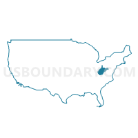
Monongalia & Preston Counties--Morgantown City PUMA, West Virginia
About
Outline

Summary
| Unique Area Identifier | 194383 |
| Name | Monongalia & Preston Counties--Morgantown City PUMA |
| State | West Virginia |
| Area (square miles) | 1,017.27 |
| Land Area (square miles) | 1,008.87 |
| Water Area (square miles) | 8.40 |
| % of Land Area | 99.17 |
| % of Water Area | 0.83 |
| Latitude of the Internal Point | 39.52515510 |
| Longtitude of the Internal Point | -79.80191210 |
Maps

Graphs
Select a template below for downloading or customizing gragh for Monongalia & Preston Counties--Morgantown City PUMA, West Virginia


Neighbors
Neighoring Public Use Microdata Area (by Name) Neighboring Public Use Microdata Area on the Map
- Allegany & Garrett Counties--Cumberland City PUMA, MD
- Fayette County PUMA, PA
- Harrison, Marion, Taylor & Doddridge Counties PUMA, WV
- Jackson, Wetzel, Roane, Braxton, Ritchie, Tyler, Gilmer & Calhoun Counties PUMA, WV
- Randolph, Upshur, Barbour, Lewis, Hardy, Grant, Pendleton & Tucker Counties PUMA, WV
- Washington (South) & Greene Counties PUMA, PA
Top 10 Neighboring County (by Population) Neighboring County on the Map
- Fayette County, PA (136,606)
- Monongalia County, WV (96,189)
- Marion County, WV (56,418)
- Greene County, PA (38,686)
- Preston County, WV (33,520)
- Garrett County, MD (30,097)
- Taylor County, WV (16,895)
- Barbour County, WV (16,589)
- Wetzel County, WV (16,583)
- Grant County, WV (11,937)
Top 10 Neighboring County Subdivision (by Population) Neighboring County Subdivision on the Map
- Eastern district, Monongalia County, WV (39,767)
- Central district, Monongalia County, WV (29,377)
- Western district, Monongalia County, WV (27,045)
- Palatine district, Marion County, WV (21,616)
- West Augusta district, Marion County, WV (17,224)
- Second district, Preston County, WV (8,708)
- First district, Preston County, WV (6,635)
- North district, Barbour County, WV (6,626)
- Fourth district, Preston County, WV (6,175)
- Third district, Preston County, WV (6,168)
Top 10 Neighboring Place (by Population) Neighboring Place on the Map
- Morgantown city, WV (29,660)
- Cheat Lake CDP, WV (7,988)
- Brookhaven CDP, WV (5,171)
- Westover city, WV (3,983)
- Kingwood city, WV (2,939)
- Star City town, WV (1,825)
- Terra Alta town, WV (1,477)
- Granville town, WV (781)
- Mount Morris CDP, PA (737)
- Cassville CDP, WV (701)
Top 10 Neighboring Unified School District (by Population) Neighboring Unified School District on the Map
- Monongalia School District, WV (96,189)
- Marion County School District, WV (56,418)
- Preston County School District, WV (33,520)
- Garrett County Public Schools, MD (30,097)
- Albert Gallatin Area School District, PA (23,880)
- Uniontown Area School District, PA (23,820)
- Taylor County School District, WV (16,895)
- Barbour County School District, WV (16,589)
- Wetzel County School District, WV (16,583)
- Central Greene School District, PA (15,921)
Top 10 Neighboring State Legislative District Lower Chamber (by Population) Neighboring State Legislative District Lower Chamber on the Map
- State House District 44, WV (89,802)
- State House District 50, PA (59,028)
- State House District 51, PA (56,731)
- State House District 43, WV (56,711)
- State Legislative Subdistrict 1A, MD (39,216)
- State House District 45, WV (22,068)
- State House District 40, WV (20,319)
- State House District 42, WV (19,954)
- State House District 48, WV (19,352)
- State House District 46, WV (18,593)
Top 10 Neighboring State Legislative District Upper Chamber (by Population) Neighboring State Legislative District Upper Chamber on the Map
- State Senate District 46, PA (235,908)
- State Senate District 32, PA (225,580)
- State Senate District 13, WV (122,633)
- State Senate District 14, WV (121,969)
- State Senate District 1, MD (118,930)
- State Senate District 2, WV (101,327)
Top 10 Neighboring 111th Congressional District (by Population) Neighboring 111th Congressional District on the Map
- Congressional District 6, MD (738,943)
- Congressional District 9, PA (666,810)
- Congressional District 1, WV (615,991)
- Congressional District 12, PA (612,384)
Top 10 Neighboring Census Tract (by Population) Neighboring Census Tract on the Map
- Census Tract 9638, Preston County, WV (6,763)
- Census Tract 6, Garrett County, MD (6,186)
- Census Tract 106, Monongalia County, WV (6,179)
- Census Tract 2631, Fayette County, PA (5,871)
- Census Tract 7, Garrett County, MD (5,726)
- Census Tract 101.02, Monongalia County, WV (5,686)
- Census Tract 120, Monongalia County, WV (5,471)
- Census Tract 9646, Taylor County, WV (5,406)
- Census Tract 9657, Barbour County, WV (5,276)
- Census Tract 210, Marion County, WV (5,275)
Top 10 Neighboring 5-Digit ZIP Code Tabulation Area (by Population) Neighboring 5-Digit ZIP Code Tabulation Area on the Map
- 26554, WV (41,369)
- 26505, WV (38,772)
- 26508, WV (29,170)
- 26501, WV (19,616)
- 21550, MD (14,194)
- 26354, WV (11,135)
- 26525, WV (7,064)
- 15478, PA (6,446)
- 26537, WV (5,721)
- 26582, WV (5,335)